Alfred's towns
The
![]()
Alfred's towns
~~~~~
The Burghal Hidage is a unique document, a list of Wessex's fortified burhs which reveals a degree of organisation rare for this period, and gives us a detailed glimpse of the system Alfred designed for the defence of his kingdom. The list we have is generally dated to the reign of Alfred's son Edward, but it clearly outlines Alfred's system as described in both Asser and the Chronicle. There are 33 burhs on the list, most of which would have been founded during Alfred's reign, and the distribution of these fortified centres meant that no one in Alfred's kingdom was more than 20 miles from a place of refuge.
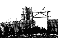
Alfred's burhs varied in size and versatility. The larger ones were apparently already established centres of population. The smaller ones seem to have been little more than forts. Asser mentions
"...the towns and cities he restored, and others which he built where none had been before"
| The typical Alfredian burh might have been a small to medium sized fortified town, some with Roman walls intact as at Exeter, some with a reconstituted Roman circuit as at Winchester, and some with entirely fresh Saxon ramparts such as Wallingford. Typical defences were turf covered earth ramparts, revetted with timber and in some cases showing evidence of pallisading. In many cases these defences were later strengthened by stone walls. A charter which details the foundation of the burh at Worcester clearly states that it was founded to "shelter all the people". |
|
Each burh in the list is assessed in hides, a measurement of arable land which in the Hidage relates to two things, the nominal garrison size, and the length of the defences. In essence, one hide equaled one defender equaled just over four feet of perimeter. The towns where we can still measure the length of the Alfredian perimeter show a surprisingly close correspondence to the Burghal Hidage assessments. The whole system, if we accept the assessments listed in the Hidage, would have required about 25,000 men, an enormous number for the time and place.
|
|
We have to qualify these figures by saying that first, they were undoubtedly an ideal, and not always achieved in every place or occasion, and secondly that these numbers represented a temporary local levy in times of need, not a standing army. The Anglo-Saxon army of later centuries operated on a levy of one fighting man for every five hides, a formula which would have given Alfred a total field army (fyrd) of no more than maybe 4 or 5 thousand men. We are told in the Chronicle that Alfred divided his army in two, so half served while the other half remained at home. This would have given him an effective standing army of only a couple of thousand at any one time. If this, plus the stationary burgware (the burh garisons), were sufficient to contain Danish activity in the 880s and 890s, then Danish numbers cannot have been very great either |
The scale and organisation of Alfred's burhs system represents much more than simple ad hoc defensive arrangements, as had been the case previously. They were much more than a local and communal defence, the Burghal Hidage indicating a much clearer centralised national effort, and there was a considerable attention to organisation and detail which is revealed by written records and archaeology.
Alfred's burhs represented a new, positive approach to defence, incorporating centralised planning and local communal effort. That they were successful militarily is obvious, but that they were also economically and socially successful is demonstrated by the number which survived the wars and became thriving towns.
England was not alone in suffering Viking raids, but the response of the Kingdom of Wessex stands alone in this period in terms of scale and success. On the continent Viking activity emphasised the impotence of the last Carolingians and contributed to the decentralisation of authority and the growth of local magnates. In England the royal house of Wessex extended it's rule over the rest of the country to create a centralised and unified kingdom.
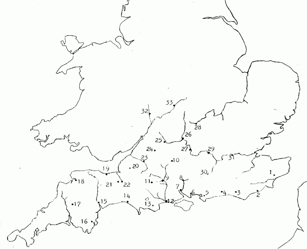
The Burghal Hidage burhs in order of their assessments. Numbers refer to Map A. Likely post Alfredian
marked with *
| 8 - Winchester 2400 27 - Wallingford 2400 33 - Warwick 2400 * 31 - Southwark 1800 13 - Wareham 1600 28 - Buckingham 1600 * 5 - Chichester 1500 25 - Cricklade 1500 9 - Wilton 1400 26 - Oxford 1400 * 3 - Lewes 1300 |
24 - Malmesbury 1200 32 - Worcester 1200 29 - Sashes 1000 23 - Bath 1000 14 - Bridport 760 15 - Exeter 734 (probably an error, too low) 4 - Burpham 720 11 - Shaftesbury 700 10 - Chisbury 700 22 - Langport 600 30 - Eashing 600 |
19 - Watchet 513 2 - Hastings 500 6 - Portchester 500 * 12 - Twynam 470 20 - Axbridge 400 18 - Pilton 360 1 - Eorpeburnan 324 16 - Halwell 300 7 - Southampton 150 17 - Lydford 140 21 - Lyng 100 |
Map A - location of the burhs - numbers refer to the table above
~~~~
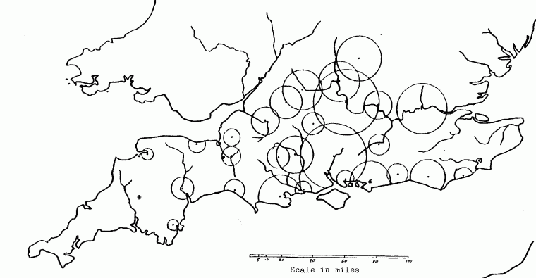
Map C shows the relative sizes of the burhs along with their geographic distribution. Note the importance of the heartland of Wessex and the Thames.
![]()
![]()
![]()
![]()
![]()
![]()
![]()
![]()
![]()
![]()
[ Celtic Monasticism | Alfred Homepage
| The Bookshop ]
[ Ogdoad's Page ]